Thursday, October 3, 2013

Mother Nature's version of Two-Face

This one has had me tingly for days and it's just not getting going with tornadic supercells ongoing in southern/southeast NE that have produced tornadoes in the last few hours. Our storm system is currently diving southeast across Idaho late this evening with strong height falls occurring across WY and CO as seen on water vapor. Several little shortwaves rotating around the main upper level low will continue to do so and eject out as PVA. Now there will be two sides to system, one with lots of snow and the other with severe weather and tornadoes in the warm sector tomorrow afternoon and evening.


As this system slowly works it's way ENE it will slowly intensify and you'll see the stronger mid-level jet core move east as well, continuing to show how strong this system really is as wind speeds at 500mb near 90kts.


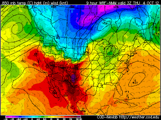
There is already plenty of moisture up into the central plains out ahead of the sfc low and as that deepens moisture, aided by the strong low level winds, will be thrown up and over the front back into the cold air to help get the deformation band of snow going. 850mb winds but in the warm sector and in the CCB will be very strong. You will have blizzard conditions into parts of western SD near the Black Hills/Rapid City.


With more than abundant moisture in place, both aloft and at the surface, lots of forcing and enough cold air, snow will begin to develop rapidly during the day tomorrow and reach peak intensity tomorrow night as the deformation zone takes shape and will almost stall out as the sfc cyclone occludes tomorrow evening allowing for heavy snow to sit over parts of SD for a long duration of time.


Some of the snowfall amounts being forecasted by the models are just insane and hard to even believe. The NWS is staying on the conservative side being the numbers are so high, it's early October so the sun angle is still fairly high as well as the pavement and ground temps so snow could have a hard time sticking as well.  Blizzard warnings are up across western SD for 7-15" with locally higher amounts as well as wind gusts to 70mph! This is all the models forecasted amount for Rapid City, SD.


Now onto the severe side of things....lots of chasers will be out tomorrow trying to see one last tornado before winter gets here next month or so. An unseasonably deep through coupled with lots of moisture (dew points in the mid-upper 60's) will great for a very volatile environment tomorrow afternoon and evening. As the sfc low deepens tomorrow across eastern NE, the sfc winds will quickly respond the the pressure falls and back along and south of the warm front with winds aloft veering around quickly with height creating a lot of speed and direction shear in the low levels. As you can see here, the sfc winds are very backed by late afternoon and evening tomorrow across western and northwest IA.


And when looking at the sounding/wind profile you can see this much better throughout the entire atmosphere with ESE winds at the surface veering to WSW winds at mid-levels.


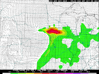
Now I haven't mentioned how much instability yet but let's just say it will be there, and in a big way for this time of the year with CAPE values climbing to 3000 j/kg in the late afternoon hours. So we have lots of moisture, lots of instability and lots of shear, both low level shear and bulk shear...but will we get discrete storms to take advantage of this environment? It can happen but I'm still worried about more parallel mid-level winds closer to the cold front and getting linear storms quickly and the amount of cold air advection just behind the cold front. I think a sleeper target is somewhere in northeast IA along the warm front where the 500mb flow is more WSW'ly allowing for possibly more discrete storms to ride the warm front but the big spot to me is northwest IA. The last image is the STP or significant tornado parameter which will combine several things like instability and low level shear to get a value of where the best chance for tornadoes and/or significant tornadoes might occur. This is valid for 7pm tomorrow evening.


Tomorrow is going to be the most exciting day in a while meteorologically speaking and I can't wait to geek out even more to it.
 
 
Matt 


Tuesday, December 18, 2012

Finally!! A legit Winter Storm!

Our first winter storm of the season is taking aim on northern IL and the Chicagoland area and will arrive late Weds Night bring at first rain to the area before a changeover to heavy snow accumulating possibly several inches along with lots of wind! A strong storm system made it's wave onshore this evening in CA as is now slowly moving eastward towards the four corners region.

As seen here on a WV loop

http://weather.rap.ucar.edu/satellite/displaySat.php?region=EVV&itype=wv&size=large&endDate=20111020&endTime=-1&duration=12

This is progged by the models to continue moving eastward across the Rockies inducing pressures to fall on the lee side of the Rocky Mtns leading to cyclogenesis of our storm at the sfc. Now that the southern stream wave is onshore the models will get a better handle on the track now given it's now in the upper air raob network. The track of the sfc low has been bouncing around the last few days. As seen below, as well as the upper level system moving over the four corners region

 
And now the wave crossing the four corners region valid 12z tomorrow morning off the 0z GFS


Now as the sfc low gets its act going the low level baroclinic zone begins to tighten and now only will the sfc low ride along this but a tigher gradient leads to quicker and stronger intensification of the sfc low.


As the sfc low begins to moving ENE out of OK it will begin pulling up gulf moisture due to a strong LLJ and really nice feed of good theta-e air up over the warm front and into the cold air as precip blossoms in the cold sector. So 24hrs from now we should have a good area of snow falling across KS/NE and into parts of IA.


Now as the sfc low continues northeast, rain and possibly some embedded thunderstorms will make their way into northern IL during the overnight hours and into the morning as it will be too warm for snow production. Heavy snow and a blizzard will be taking place in parts of IA and WI by Thursday morning where it will be cold enough for snow as well as strong low level winds in the CCB creating blizzard conditions. Also looks like there will be some enhanced banding and even possible thundersnow.
 
 
Now is the fun part of this event, atleast for us in northern IL. Some models are hinting at second deformation zone developing in northern IL during the afternoon and evening hours on Thursday and the sfc low rapidly deepens near and just to our east. The pressure gradient really tightens creating strong winds along with heavy snow falling across the area. Now these next few images are pretty impressive. You have 60kt winds in the 925mb layer, that is beyond rare to get in the CCB of a winter storm, unless its the GHD blizzard! Then you go up just a tad and you have 75kts! And with any possible convection (thundersnow) it's not going to be hard to mix those minds down to the sfc. The 0z GFS is progging very impressive UVV's (lift) during the afternoon Thursday across the area. Not a given that we'll see thundersnow but it's something to watch.
 
 
top left image valid 18z Thursday and other two valid 0z Thursday night.
 
Now for totals....this is the tricky part....a lot of variables like time of changover, track of the sfc low, is amount of CAA underdone or overdone, dry-slot etc. I'm sticking with 2-4" right now, more up near the IL/WI and less down near/south of I-80. Any shift in the storm track will have big implications on those current totals.


Matt


Wednesday, October 3, 2012

Snow forecasting is back!

It's looking likely now that an early winter storm is going to hit late tonight and tomorrow across the Red River Valley across parts North Dakota, Minnesota and into Canada. Over the last 24 hours the models have come into much better agree on strength of the system, placement of the heaviest precip (snow) and intensity of that in the deformation band. NWS offices up that way have issued winter storm watches and warnings for snow accumulations of 6-12"

As usual I'll start off with a WV loop of what's going on..

http://weather.rap.ucar.edu/satellite/displaySat.php?region=EVV&itype=wv&size=large&endDate=20111020&endTime=-1&duration=12

Our shortwave is still back in eastern MT with jet max moving across parts of WY and into the Dakota's later this evening. A good amount of dry air seen south of this system and also what looks to be the uppel level jet screaming along near the WY/CO at the base of this trof with a bit of divergence seen as well. It's going to take till overnight for this thing to really get going and the mid-level low to close itself off but when it does we should see an expansion of precip in the deformation zone. As you can see below is the mid-level shortwave closing itself off and intensifying tomorrow morning as it moves into MN.


What is feeding this thing is the tight and impressive low-level baroclinic zone for it to ride along and feed off of. With it still being only early October there is still plenty of latent heat to be tapped. 850mb temps of 14 deg C into the circulation is damn impressive. Also much colder, canadian air will be dragged down.


What will determine amounts will not only be what the SLR ratios are (probably around 8:1) but when the changeover from rain to snow occurs. Now based off soundings and looking at thickness values, it should be somewhere between 6-9z overnight depending on a given location.


Overall this system should looking very impressive on both WV/sat as well as radar. Here is a forecast comp reflectivity (sim radar) for early tomorrow morning showing the large area of precip associated with the deformation zone


Another thing to watch will be possible areas of blizzard conditions. It's not a setup that screams blizzard but models have been progging 925mb winds anywhere between 50-60kts...and if those are to mix down to the surface then obviously there could be a short period of blizzard conditions given the heavy rate of snowfall. Here is a forecast sounding for just west of GFK showing the potential and extreme winds just off the deck.


Add to that we could see snowfall rates of 1-2"/hr in the heaviest band given the strong UVV's being shown on fcst models, I wouldn't be shocked at some thundersnow either. Another thing when looking that sounding above is the depth of the dendritic growth zone (DGZ) which will tell you how well good a state the atmosphere is in making bigger snowflakes of dendrites. Looking like a >100mb deep DGZ for time which is fairly impressive.

Here is the 15z run of the SREF forecast snow totals which really ramped up from the previous runs. Will be interesting to see if this trend holds over the next few runs.


If I had to pick a max band area I'd say from near/north of GFK to extreme southeast Winnepeg near Lake of the Woods. I'd love to be up in northwest MN for this one. Anywhere from 10-14" looks like a good bet in that area. It will be a quick moving system but man is it going to pour snow. Things to hamper with totals will be warm ground and time of changover. But hopefully heavy rates will compensate.


Matt

Sunday, July 22, 2012

Forecast for tomorrow 7/23/12

Well tomorrow looks interesting in several ways regarding both high temps and possible severe weather tomorrow evening and into the overnight hours. Question is, do we awake to full sunshine or to being socked in clouds like we were today which kept temps down until the late afternoon hours. Currently there is some scattered unorganized convection on top of the ridge firing on the nose of the LLJ out in the northern plains with a few showers around here. Right now I'm favoring a sunny start to the day and temps should climb pretty rapidly into the mid 90's and possibly even warmer if we stay sunny into the afternoon nearing 100 degrees. Sitting under the 850mb thermal axis it's not going to take long to really heat up if we have sunshine with deep mixing.

This surface heating is going to lead to a lot of instability in the atmosphere and juice for possible storms to tap later on. Some forecast models have a piece of energy or shortwave cresting the top of the ridge, associated with stronger mid level flow (35-50kts) moving into are area by late afternoon/evening. *IF* storms were to form thanks in part to this wave, they would have the potential to be severe with damaging winds the primary threat. Looking at one model, perfect prog of the 0z NAM blows up a ESE moving MCS around DBQ and pushes it across southern WI/northern IL after 7pm. If that were to happen the mean wind and instability gradient would favor this area. But, some models have these storms further north so we'll see.

A lot can go wrong with this forecast...we could wake up to clouds and only make it to 90 degrees and that would screw up storm chances later on in the day.


  I'll go with a high of 97 at ORD

Wednesday, June 27, 2012

A little bit of forecasting feels good

Well it's been awhile....here goes.. Most places will hit 100 tomorrow, except maybe up in southeast WI and the lake breeze will get to that area first but we'll see. Sitting under/near the 850mb thermal axis in the morning should really give this area a good head start and allow for temps to rapidly heat up quickly and possibly near/at 100 by 18z. I said 102 at ORD so we'll see how that pans out. Places further south like PIA/BMI/SPI will be warmer, possibly 105-108. I'm curious to see the quality of the low level moisture we get given it's been god awful dry around here but the GFS has been the best model the past two days in relation to sfc dew points in the central plains and in IA today where the NAM/RAP were 5-10 degrees too low this afternoon. The recent heavy rains out there the past few weeks might be playing a role in that though, but dew points of 78-81 were realized in IA today like the GFS had and that model is the most bullish for IL tomorrow pooling upper 70 to near 80 dews along/north of the boundary. If we get those realized with temps near/over 100, the HI readings will be a lot higher than what are being forecasted right now. And to be honest it kind of ticks me off that some offices are discounting the more bullish solutions of the GFS regarding moisture right off the bat saying quality of moisture is in question blah blah blah. So a part of me hopes we see higher dew points for just that reason. DSM got burned today riding the NAM and under forecasted dew points in the western half of IA. Now about convection chances..I'll start off by saying I'll be surprised if both the lake breeze and/or the E-W frontal boundary doesn't pop storms between say 22-6z late in the afternoon to around midnight. Yes we have a fairly strong cap but it's breakable IMO. Models are all over the place with many solutions as to how things play out and I've looked at most to get an idea. The 4km WRF has a whole lot of nothing, the NSSL WRF lights up the lake breeze by 22z with a likely supercell to MCS transition, the WRF ARW has a big eastern IA-northern IL MCS overnight. It's going to come down to real analysis tomorrow watching the WV loop trying to pick out any little ripples in the flow along the srn fringe/north side of the ridge tomorrow afteroon. Models are hinting at some CAA at H7 late tomorrow with hints of weak ascent but will convergence be enough? Tons of sfc heating but will storms go and if they do, do they fully breach the cap or struggle and die? Right now I think we have a better shot at seeing convection fire off the frontal boundary in IA and tracking eastward into IL during the late evening/overnight hours. I'm a bit more iffy on lake breeze storms right now. SPC going with a "see text" for now and I think that's a good call until further mesoscale details are resolved. Matt

Wednesday, April 18, 2012

4/14/12 Kansas tornadoes chase summary

I have been wanting to do this for the last few days but have been quite lazy so here it goes. I believe this day first caught my attention Weds morning when the NAM came out showing a potential tornado outbreak across the Plains on Saturday. I had somewhat of an obligation on Saturday but had the chase itch and needed to get out. Once the Day 2 High Risk came out during the early morning hours on Thursday, that pretty much made my decision on what I would be doing this weekend.


So my chase partners (Ryan and Jim) and myself started making plans to leave Friday evening and overnight in Des Moines, IA to put ourselves in better position. I haven't had the best luck on high risk days and don't really like them given they are are a jinx in the chaser community, lots of chasers and usually lots of storms.

We woke up Saturday morning jacked and nerves high knowing the potential of this day, did our analysis and headed west on I-80 and entered Nebraska during the mid morning hours. This was a first time for all of us chasing on a day with 45% tornado probs. We decided to head south out of York, NE and make our way into KS.


Our initial area we liked was Concordia/Salina and wish we stuck to that. By noon the dryline over western KS was already setting off elevated storms (this would go on to screw up the northern target in Nebraska and limit instability) and the SPC issued a PDS (Particularly Dangerous Situation) tornado watch with these storms forecasted to become surface based later in the day and pose a risk of strong, long-track tornadoes.


We got antsy and went to have a look see at the first tornado warned storm of the day west of Belleville, KS. It turns out this storm didn't look that great and we made the bad mistake of taking an east option onto a gravel road east of the notch...gravel quickly turned to mud on the other side of a hill and we had a close call going down said hill but thankfully were okay and now had to get back up the hill which was mostly mud. It took us about 4 attempts to get back up and get south. If that road took anymore water we would have been mostly done for the day.

At this point new development off the dryline was occurring in southwest KS and this was the start of the show. We headed south out of Beloit, KS and made our way to Great Bend to gas up and had to make a decision between two supercells heading northeast at us.


We chose the southern sueprcell that would head for St. John, KS and had reports of producing tornadoes. We intercepted it west of town and it at the time looked HP and outflowish. It was either stay with this one or drop south to another supercell coming up. We headed south and waited for a supercell coming up to the Pratt/Cunningham area.


This storm looked and felt better (strong inflow) but wasn't heading into the updraft, more offset to the right. We saw several funnel clouds off the the southwest miles away. This storm was also crawling and started to develop a nice inflow tail into the area of interest...a weak, scuddy wall cloud formed but thats about as interesting as it got.


We ended up heading north for awhile keeping with it but it never got going any further and we decided to blast north to another supercell which was producing tornadoes left and write. We were waking up a lot of ground and figured we would catch it near Salina, KS.

radar image at 6:30pm (at this time we are near Sterling, KS)


We continued northward then east to I-135 and were glad to see the speed limit jump to 75mph as we booked it north to Salina and east on I-70. Right before we got to 70 we could several several funnel clouds to the east and knew this thing wasn't done. We continued on I-70 east with the meso just north and spinning nicely and we were quickly greeted to our first tornado, albeit brief.


And only a few minutes later we had another tornado quickly come down just north of I-70. This was perfect and by far my most rewarding tornado to date.


We then exited the highway and headed north as the tornado continued to get larger in size.


gorgeous rope tornado looking north


Solomon, KS tornado video

http://www.youtube.com/watch?v=Y3SmiR7HxWY

Manchester, KS rope tornado

http://www.youtube.com/watch?v=ZVYli4sDDMk

Overall it was a great chase day and very rewarding given we were on many storms driving long distances and they just weren't producing for us.

And my first Kansas tornadoes!!!

Wednesday, January 25, 2012

Upper air loops of the 1967 Chicago Blizzard

Skilling getting a lot of info for this storm to go on the Tribune weather page for tomorrow so thought I would put up some loops really quick.

Whats amazing is how slow it moves once you reach 12z on the 26th.

how to make gifs
href="http://picasion.com/">

how to make gifs
">