Thursday, December 2, 2010

Old Man Winter...."I'm Back"

Well we have got off to a late start in the snow department here in northern IL so far but it seems like as we turn the page to December we really start seeing the snow flying. After the first measurable snow the other day of 0.1" we should blow way past that total with this snow system coming for tomorrow night into saturday. This is our first sizeable snowfall of the season

This is a clipper like system but not a real clipper as its not going up around the ridge and the sfc low diving southeast pretty quickly like a typical clipper des. Its more of the 850mb low and the track of that with the sfc low being further south moving southeast to ESE across the central plains and into MO and then KY with band of snow on the northside closer to where the 850mb low is.

sfc low track


As this sytem is getting its act together warm air advection will be taking place and running up and over the cold air causing snow to break out in a northwest to southeast oriented band streaking to the southeast along the 850mb low track and into our area by late tomorrow night with the heaviest snow falling from about 10pm to the late morning hours on saturday with possible lake enhanced/lake effect snowfall after that in the afternoon and evening.


There are things working for this system and things not working to help create a good snowfall. Its going to be a quick hitter, probably a good 12 hour period of moderate snow but the snow ratios will be around 13/14:1 which will be a powdery type. There will also be good snow growth given the depth of the DGZ. There is also could be some nice fronto banding which would aid in heavier snowfall rates.

here is an image showing the amount of lift going on in our snow system


this is a map showing the probability of the depth of the DGZ being greater than 100mb allowing for good snow growth


Another thing to watch for is a possible meso low forming out over lake michigan and even coming onshore which could enhance snowfall amounts near the lake saturday afternoon and evening. meso lows are more favorable in weak synoptic flow environments, which is what we will have on the north and northeast side of the 850mb low. The flow from surface to 800mb is weak easterly to northeasterly flow, with no significant flow above that until you get up to about 600mb.

here you can see the LSX WRF picking op on a possible meso low moving down the lake and actually comes onshore in northeast IL


as for amounts, Im still riding my 3-6" call from yesterday for area wide with heaviest near the lake due to lake enhancement/lake effect snow and guess LOT will go with a winter weather advisory for tomorrow night into saturday afternoon. here is an image of total QPF run off a hi res WRF

Friday, November 12, 2010

First heavy snow event!!

Well I haven't posted in quite awhile and there has sure been some events where I should have, but now we have snowstorms to forecast and watch and this is what I love doing, being up to my neck in data. So even though the first good snow event of the winter, or should I say fall...(with temps in the 60's and 70's here this week) isn't over northern IL, I am still geeking out of this system because it is fairly impressive and should have some moderate to heavy snow accumulations associated with it beginning tonight and through the day tomorrow from northwest IA to southern/central MN to to norhwest WI by tomorrow night.

Like always I will start with the 24 hour WV loop

http://weather.cod.edu/loops/US-WV24.loop.html

We currently have our upper level trof moving into the midwest with well defined vort max over the NE/IA border reflected by the closed 700mb low. this system has been moving northeast throughout the evening and intensifying nicely as it does so. precip has also been steadily increasing in coverage and intensity from northeast KS up to the MN/IA border. The temperatures in the area have been dropping throughout the afternoon and evening but are marginal for snow but due to some good CAA going on and the intense precip rates, rain has been able to changeover to snow in some areas and has been quite heavy at that with a few lightning strikes in the OAX area earlier due to CCB's

At the time before that, the temps were above freezing up to 800mb but due to the insane amount of insentropic ascent going on, the 925mb temps crash 3 to 4 degrees in an hour which lead the the BL temps to cool below freezing to allow for snow to reach the surface. This is what happened this morning in AMA where they had +TSSN with the column not supportive of snow but due to the amount of convection, it was able to make it all the way down.

Here is the 0z OAX sounding..


Over the past few hours the deformation band has really began to take off and areas have began to changeover to snow and the temps/dew points slowly drop to near or below freezing. There is a really nice moisture plume that is feeding northwestward into the colder air. It looks like the snow axis will follow the H85-H7 frontogenesis axis. Also, the dry slot was filling in with precip from southeast NE up into southwest NE.


The deformation band will continue to move northeast overnight into southern/central MN where there are currently winter storm warnings in place for 6-10" of snow. I wouldn't be suprised if there ended up being a total near a foot given the intense precip rates/possible thundersnow due to it being pretty unstable aloft, and the dynamics this thing has going for it. all in all, a nice, intense first snow system to forecast for.


Hopefully this is a sign of things to come this winter!


Matt

Sunday, August 1, 2010

tuesday potential on the home turf??

well tuesday looks very interesting looking at the new NAM. MCS moves across western/central IL during the morning/early afternoon hours most likely laying out a nice boundary with storms going on that in the evening. mid-level flow is alright between 25kt-35kts but the low level shear is quite good given the strong 850's in the area and you add big amounts of instability and upper 70's dew points with a sfc low in southeast IA and you got a problem. have already looked at some soundings and the GBG and PIA soundings are quite nice with good turning. the CAP might be a problem with H7 temps between 12-14 and CIN at -49 on the GBG sounding at 0z.

will post more later on the setup.

will not be able to chase though due to work.

Monday, July 12, 2010

write up for tues/weds severe and tornado potential

Well as much as it hurts to look at the forecast models for the next few days since I can't chase I still will do it anyways cause I love to forecast these events. Weds looks to be the bigger of the two days but tues still looks pretty descent in the dakotas.

As a upper trof moves in from the west with better mid and upper level winds associated with it, moisture will begin to return from the south and west as a dryline sets itself up in the dakotas and further south into NE. As Victor and I were just discussing tomorrow looks tough as it looks like maybe two possible targets. One being down possibly in NE where the better instability and moisture is being pegged but away from the better mid-level winds or playing further north in eastern SD under the better winds but less juice but still sufficient. I personally like the northern target with the better wind profiles but as Victor said further south "big CAPE kicks big ass"

500mb speeds at 0z


MLCAPE at 0z


As a target for tomorrow I like Mitchell with possibility of heading north.

Now comes the fun part or day for that matter. I will just go out and say it, play nw KS on weds! It would take some real kahonas to blow off MN/IA and do that :) but I wouldn't considering this setup is going to be a repeat of 6/17 in the AEL area. This setup just looks "good day" 50kts from the WSW at H5, good strong SW H85 winds and nicely backed sfc winds into southern/southeast MN and northern/northeast IA. As Victor pointed out, there looks to be a diffuse warm front from southern MN down across northeast IA. The wind profiles in that area are mmmm good. 0-1 SRH AOA 200 in northeast IA at 0z and only gets better as time goes on.

12z NAM showing CAPE values AOA 3500 j/kg with dew points in the mid 70's possibly nearing 80!


thank you corn!


just look at that theta-e! wow!


Target for weds- sit in AEL to possibly head east on 90 or south on 35 to head into northern or northeast IA.

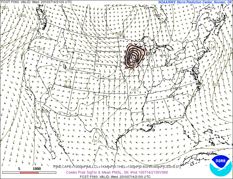
One last images to look at for tornado potential off the 9z SREF for 21z on Weds. last time a 50 was shown...4/22...5/10...6/5


Matt

Friday, May 21, 2010

sleeper day in CO??

The new 12z WRF is showing a nice signal for the TX PH but I really dont like the weak upper level winds as well as what the LCL's will be in that area. Its going to take quite a bit of convergence along the dryline to get something to go. The H7 temps are progged to be quite high. I wouldn't rule out that area for an isolated storm later this evening but I like the northeast CO play alot more.

Like the Brush to Yuma area for supercells later this afternoon. dew points are already in the low 50's in nw KS/ne KS/nw NE per the 16z obs. The shear is amazing in the area with really nice low level hodographs. will be interesting to see if a denver cyclone can develop later this afternoon.


We are leaving Garden City now.

Thursday, May 20, 2010

4 tornadoes in TX Panhandle on Tuesday!!

This day had alot of promise in the TX PH with upper level flow finally kicking out into the plains with a trof coming in with descent moisture streaming into the PH with moderate instability in the area with a wave progged to move in during the late afternoon hours. We headed to Dalhart, TX for our intial target where we ate lunch at decided to sit there for awhile thinking that was a good area. We decided to headed a bit northwest west to Clayton, NM where we could get a better view out to the west where we thought CI would occur with the wave coming in. On our way there we noticed some TCU in the clearing to our southeast near Channing, TX. A few minutes later echoes started showing up on radar and it was going up fast. We decided to bust south to it not knowing what it would do but it was in a good environment for development. We caught up to east east of Channing and pulled off the road past some of the Vortex 2 crew to watch it.


It was developing into a very nice supercell rather fast right in front of us and had good inflow into it most of the time. It was sucking up alot of scud with a nice RFD to our west and soon began to develop a wall cloud with numerous areas of interest.


It really started to get its act together as it started raining but soon had rain falling into its updraft so we headed east to give it time. About 3 minutes after leaving this location some people spotted a tornado back to our west as we were driving east we spotted a tornado coming down. Only a few got pictures of it as it was brief but was tornado number one. After this is when all the hordes of chasers. There were so many chasers between Vortex 2, locals, the Discovery Channel idiots, tour groups, and others out.

We ended up southwest west of Dumas, TX and pulled over to continue to watch its development. At this point it never screamed tornado and never had the classic clear slot RFD occlusion. Most of the time it looked shelfish as it looked like a HP mess for awhile with it raining into the mesocyclone.


After this we headed through Dumas and then east. This took quite awhile with so many people out and having to go through a town. As we got onto the road out of town we spotted a small tornado back to our WSW. There were reports of a large tornado in Dumas but we didnt see it and dont believe it considering the one we saw was small and brief and just south of town. We continued east with other chasers to get a good view of it and went probably about 10 miles east of Dumas and stopped and were rewarded to amazing structure with the supercell, It was amazing in its own.


After about 5 minutes at this location, hail began to fall out east of the storm due to the strong upper level winds. We headed back east for a few miles and went south of the main road where all the chasers were to get a nice view of the storm by ourselves with nobody around.


On Tuesday our target was the TX PH as we left LBB in the morning and headed for

This thing was turning into a HP mess with alot of rain falling into the updraft as time went on which meant you had to be on the northeast side of the meso to see anything. We continued to follow it to Stinnett where it was a mess with alot of chasers.


We decided to leave this storm for a rapidly developing supercell near Romero, TX. We busted back west and finally caught up to it just northeast of Dalhart at right when it became dark and was throwing out cold air....so with crappy lightning we decided to leave and head to the hotel but as we were heading east low level rotation increased quite a bit and inflow picked up so about after 10 seconds of looking north while driving for lightning flashes, someone saw what looked to be a tornado off to our north illuminated by the lightning. It ended up being a pretty good size tornado a mile from us. It was on the ground for around 5 minutes before lifting. It was so great getting my first night tornado I couldn't of been more giddy.

We went east again with a supercell northwest of Stratford showing descent rotation show we went north to check it out but were having data problems but were still able to get radar on Victor's phone. The area of interest was pretty close to us as we were nearing the town. We stopped to get gas where hail was covering the ground and we were actually not allowed in the gas station due to the weather im guessing.


The storm slowly moved south and we were just south of town when the storm was just east of town when someone spotted a tornado thanks to the lightning behind us. We got out and sure enough a large tornado was on the ground with inflow winds probably around 40mph! That was the 4th tornado of the day! It was my best chase day and was so much fun.

Write up for the next day in OK coming soon!


Matt

Monday, May 17, 2010

day by day...by day...finally we have better UL support

The last few days we have been playing around with ok storms in southeast NM and southwest TX. Yesterday we were around I-10 and fort stockon to sanderson killing storms that were already crappy. Today was the best day so far as we caught a few nice storms near Carlsbad, NM. They were big hailers which we stayed out of but did give us some descent structure to enjoy and well as some good lightning, was nice to be actually chasing again.


The problem with each day has been the overnight stupid convection that has went through the area and scouring out everything and making it harder to recover the next day. this past saturday looked great the day before but due to an MCS it sucked. As with the setup for tomorrow, that is going to be the problem once again. We finally have a nice trof coming into the plains with good mid level winds and a dryline at the surface but the new NAM is breaking out alot of precip during the morning and early afternoon from southern CO to eastern NM/TX PH. This cutting down on the amount of destabilization to occur and moisture return.

500mb flow tomorrow evening


Weds looks like a good day in OK and possibly northern TX around the childress to wichita falls area but what happens tomorrow night will have an effect on the next day. Thursday looks like a travel day further north with more chasing once again friday and saturday before heading home on sunday.

dew points weds evening