Monday, December 12, 2011

GR level 2 radar loops of strong tornadoes-Joplin and Greensburg to start

With the current boring weather pattern I thought I would put together a few radar loops from different strong tornado events. I will start off with two monsters that happened in the last four years.

5/4/07-Greensburg EF-5

One of my favorite tornado events of all-time to go back and look at. Analyzing the entire synoptic and even more, mesoscale setup is amazing to me and how the hodograph dramatically near dark, left split after left split after left split then BOOM. The loop of the Greensburg supercell and its associated strong tornadoes is probably my favorite 4 hour loop of all-time. Whats amazing this the amount of occlusions and new mesocyclones that went on to produce more strong tornadoes, some at the same time. As you can see in this loop, the mesocyclone and Greensburg tornadoe starts to occlude just before hitting the town of Greensburg and begins to turn north and eventually northwest while the new meso really intensifies just east of town.

create avatar
Create avatar">

5/22/11 Joplin MO EF-5 (Joplin marked by the red dot)

The environment suggested the possibility of strong tornadoes in southwest MO but what amazes me is how quickly it spun up and you can get a sense in some of the videos of it showing it going from a funnel to a full blown wedge in seconds. You can also see the insane debris ball as debris was lifted up into the tornado aloft and picked up by the radar.


make an avatar
Make an avatar

Monday, November 21, 2011

12z Euro run Ensemble Prediction System (EPS) aka The New Hotness

I'm bored so thought I'd throw together a quick loop of this run showing a major snowstorm during the first weekend of December. Yes it most likely will not verify and the system in model land is still two weeks away but I couldn't resist. But...this run which goes out to 360hr is very active with enough cold air to work with.

"Control run of the 51 member ECMWF Ensemble Predition System. This is not an ensemble mean"

how do you make gifs
animator gif

Saturday, October 29, 2011

0z GFS run...a run for the ages for next weekend

Well the models have been progging a trof in the Western US by late this coming week and have been advertising some serious cold air up in Canada to come on down into the northern plains with a strong wave developing and pushing northeast into the central plains bring up lots of moisture with it. And due to the extreme cold air entering the U.S from the north and alot of warm and moist air from the south, this is creating a serious baroclinic zone for this possible storm system to feed off of and track along. I won't get into serious details because its still 7 days out and lots can and probably will change in model land but some of these images are just insane..

H5 vort and winds showing the 120kt mid-level jet and very strong wave, the 80kt LLJ, 60 dews getting up into IA and northern IL and the 983mb sfc low in northwest IA.

It doesn't get more impressive than this for a system to produce both good severe weather and an impressive snowstorm on the cold side.


Wednesday, August 10, 2011

5/18/97 Northern IL tornado event-Linderhurst F2

Once I really got into weather I knew I had to go back and figure out what storm it was that scared me to death and hit the area and my town while my friend was over that evening. It was as also tornado warned and the sirens were very loud and I can still remember them to this day. I was seven years old at the time and lived where I still do today, in Batavia. This was one of those events that really got me interested in the weather at a very young age. Every weather nerd like me has "that event" when they were younger that they still remember. This is mine.

This day started off like alot of severe weather days around here...we had convection fire in northern IA in the early morning hours around 12z and develop into a nice storm complex as it headed into southern WI and northern IL but began to weaken as the LLJ faded and mid-level temps warmed. Although the convection died off, we still had clouds leftover to deal with before we began to destablize later in the afternoon. And just an FYI, there aren't any sfc maps from this day...only go back to 1998 on Plymouth's site which is kind of a buzzkill.

14z satellite image


Around 15z or so we began to slowly clear the clouds and have the almost June sun doe its job in heating up the atmosphere and it didn't take long before we had some real progress going on.

18z satellite image


We continued to destablize and by 20z, we got our first hint of DMC in central/eastern IA with a very strong mid-level jet pushing eastward and into the area creating more than enough, and actually quite alot of shear for supercells later in the day.


Quite the jet for late May...a 65kt weserly H5 jet at 0z that evening


Here is the 700mb chart, decided to contour some of the H7 temps to show you the thermal ridge/EML and also put the main jet over the area. H7 temps of 8 degrees C in the area were good until to hold off convection till just the right time in the afternoon.


Storms very going up like crazy in central/eastern IA that eventally pushed into WI/IL by late afternoon and looked very healthy on radar with a tornado watch already issued for that area with a new one likely further east.


As these storms pushed further eastward into IL, more storms fired further to the east along the WI/IL border and with the strong mid-level jet overhead and strengthening 30-40kt LLJ near 0z, the environment became very favorable for supercells and tornadoes as low-level shear increased and created curved and looping hodographs. Also, DVN and ILX both had 35kts at 925mb on the 0z raob soundings, very impressive.


By around 23:30z we had our first legit supercell near Woodstock, IL with a strong meso but there wasn't a tornado reported with this storm, even though it was very impressive for awhile. At the same time, we had the second supercell and associated meso beginning to get going further east.


Here is the VAD wind profile from KLOT at around the time of that image to an hour or so before it. This is exhibiting a veering signature near the boundary layer with increasing slightly veering winds through 3km. We had 0-3km helicity values of 420 m2/s2.


About 30 mins later or so the 2nd supercell to the east become dominant and really took off as the LLJ continued to strengthen and the low-level rotation beginning to really increase as it approached to town of Lindenhurst. This is about at the time right after the tornado dropped just west of town


This tornado went on to produce F2 damage in Lindenhurst.

zoomed out radar image at about the time of the tornado and you can see the red box across the area.


I will continue to do other discussions/write-ups on other northern IL tornado events from the mid-late 90's up to around 2005.


Matt


Sunday, February 20, 2011

All aboard the wave train

Currently a sharp warm front sitting across northern IL right now, just about south of I-80 at the moment with the sfc low at 997mb sitting in southwest IA.


As we continue in this active pattern there likes to be atleast 2 more potential big storms for us in the next 7-10 days with a possible small snow event tomorrow night. The models have been going back and forth with the strength and placement of this second wave coming out tomorrow. The problem is trying to figure out if and how much snow is associated with it. The past few runs of the NAM have been showing it further north solution bringing a sfc low from OK through southern MO and then into KY with snow displaced pretty far northwest of the low center and giving us a decent snowfall tomorrow night. The GFS has brought it north but not far enough to give us any real accumulating snow from it. LOT with their new afd monitoring this potential closely calling the NAM an outlier right now spitting out near 5" in some areas and this will have to be watched closely. The new 18z GFS pushes snow a bit further north tomorrow giving us maybe a few inches.

18z NAM for tomorrow night showing the snow over northern IL


The next one that looks to hit somewhere in the midwest thursday/friday is currently off the coast of BC out in the pacific and is forecasted to dive south into the pac NW and and continue south off the coast of california. The GFS/Euro are in pretty good agreement with this one and they both then turn it east and eject the wave out of AZ/NM and into the plains. The NAM is close to the other models regarding the placement of the southern stream wave at 84hrs but it has the northern stream system diving a bit further south. Although it doesn't look that impressive aloft, given the continuation of a strong baroclinic zone across the plains and into the midwest, this still has potential to be a strong low level cyclone. both models are bringing it down to around 996mb (12z GFS is a bit weaker but previous runs have been showing it stronger) and I think a stronger solution is a good possibility given the baro zone and it will have a good deal of moisture to work with. we dont need these really strong ULL's to get a big system, look at this current system, strong thermal gradient for the storm to ride along and we get a strongly forced frontogenesis band with heavy precipitaton for alot of areas in the midwest.

12z Euro showing the system late this coming week


This is like the book "And then there were none" haha but counting up, not down. The Euro/GFS/GEM all have been advertising another big system with a trof diving down into the west next weekend and kicking out into the plains going nuetral and eventally neg tilt looking quite impressive on the Euro. It is still far out to get into the details but the potential is there and with the system after system coming out, each one has to be looked at. Can't help but wonder what tornado season could be like if we stay active getting into april/may with abundant moisture.

H5 pattern showing a impressive negatively tilted s/w trof, 12z Euro


not to get ahead of ourselves but there are more storms after 216hr but no point in talking about those....yet.

Tuesday, February 1, 2011

The biggest snowstorm of this weather geek's life

I have been watching this thing for almost 10 days on the models and its finally happening...the biggest snowstorm of my life is bearing down on northern IL as I write this 5" is down in the past 90 mins in Ottawa, OK. That is only a sign of things to come up this way as we head into the evening and overnight hours. In order for us to have got this storm we needed the northern stream wave to phase with an intense pacific cyclone that came onshore over southern california sunday and moved over the four corners region during the day yesterday and is now currently over the southern plains.

you can see it here on the 24hr WV loop..you can see it already has a textbook look to it with the moisture available really starting to show itself. Everything about this storm is epic. This is seriously the most excited and giddy I have ever been over a single weather event. The ONLY negative about this storm is the speed, and I wouldn't even call that a negative, just me wanting it to last longer.

http://climate.cod.edu/loops/US-WV24.loop.html


The moisture with this thing is absolutely insane coming off the gulf and feeding into this system thanks to a 850mb jet over 80kts! That is a very rare! This is going to make the freezing rain potential even worse. Your going to have the warm air around 850mb running up and over the cold air and the surface creating an ice storm in parts of IN/OH.


]I'm not going to make this thing super long since the storm is already going but here you can see the radar and how massive and epic it already looks..

http://radar.weather.gov/Conus/full_loop.php

Another story is going to the strong winds with this storm as it begins to wrap up later this afternoon and into the overnight hours. As you can see on the sounding we have 65kt just off the deck that are going to try their hardest to mix down later on. We will have 50mph gusts up here coupled with very intense snowfall rates possibly nearing 3"/hr...here is a forecasting sounding showing the very strong winds..


What is going to be the coolest thing about this storm is the good possibililty of thundersnow occuring during the evening and overnight hours. Here is a section of the morning AFD from the chicago office (LOT)

PART TWO OF THE STORM WILL BE WITH INTENSIFYING TROWAL/DEFORMATION ZONE TONIGHT. UPWARD VERTICAL VELOCITIES ARE FORECAST TO BE ALMOST OFF THE CHARTS TONIGHT AS UPPER TROUGH CLOSES OFF INTO A NEGATIVELY TILTED CLOSED/COMPACT MID LEVEL LOW AS IT LIFTS NORTHEAST TOWARD SOUTHERN LAKE MICHIGAN BY EARLY WEDNESDAY MORNING. ALL INDICATIONS ARE THAT VERY INTENSE SNOWFALL WILL DEVELOP WITHIN THE DEFORMATION BAND WITH TREMENDOUSLY STRONG UPPER LEVEL DIFLUENCE AND DIVERGENCE AHEAD OF THE DEEPENING CYCLONE. FORECAST SOUNDINGS SUGGEST THAT VERY STEEP MID LEVEL LAPSE (NEARING 8C/KM) ASSOCIATED WITH THE VERY COLD TEMPS ALOFT WILL PROVIDE FOR SUFFICIENT INSTABILITY FOR EMBEDDED THUNDERSTORMS TO DEVELOP WITHIN THE TROWAL...LEADING TO LOCALLY ENHANCED SNOWFALL TOTALS. IN FACT...SEVERAL MODELS SUGGEST THAT MUCAPES OF 100-200 J/KG WILL DEVELOP WHICH MEANS WE COULD ACTUALLY SEE UPRIGHT CONVECTION DEVELOP.

as for amounts...I really think some places are going to have a shot at 24" with this thing trending a bit more northwest and stronger...so right now I'm going to go with 16-24" given the trends in the hi res models and current radar, sat, etc.

HRRR...

5pm, intense snow moving into northern IL.


can probably bet on some thundersnow in this..11pm


RUC..

showing 20"+..


As this sfc low continues to track northeast later this afternoon/evening the snow should start here around 2pm or so and conditions will begin to deteriorate very quickly and could make the rush hour very bad.

I could post a 100 images about this storm..

9z SREF 12hr mean snowfall amounts....15" in 12hrs..other images are also showing 10-12" in 6hrs and 6" in 3hr..this is going to be soooo epic!


All in all this looks like it "could" make a run at the record snow total from 1967 where 23.1" of snow fell..

one more image just put out my SPC

Its beginning..


Oh and by the way...there is a tornado watch out in the south in LA/MS.


Matt

Saturday, January 1, 2011

My Top 10 weather events of 2010

After turning the clock to 2011 today I thought I would go back and pick out my top 10 events I chase and/or documented this past year. I know I didn't have as an exciting year as others chasing wise and seeing alot of great tornadoes this year but I do think mine was rather exciting seeing my fair share of tornadoes and seeing alot of good events close to home or "on" my house for that matter.

We had a pretty good winter here with alot of good snow events and the good luck seemed to continue right on into spring seeing alot of great storms and tornadoes in the plains, bagging some tornadoes on the home turf and some good events back home in the late summer months. This was probably the best year I can remember for storms in northern IL that I have been apart of.

10. May 7th- early morning thunderstorms on my birthday. It looked like for a few days leading up to my birthday that there was going to be a pretty good chance of some rumblers during the morning hours so I was pretty excited. It was an hour past midnight and storms were moving in from the WSW and I was hoping they would be good enough to produce some descent lightning. And sure enough they did, giving me an early birthday present that morning. Also, videos take too long to upload on here so I'm just going to put up the youtube links for them.


9. January 8th- During the early morning hours an intense LES band making its way all the way inland to eastern Kane county producing the heaviest snowfall rate I have seen while living in Batavia, 1.1" in 20 minutes. I was watching this band for atleast 2 hours on radar hoping it would make it out here and when it got here, it poured snow!


http://www.youtube.com/user/MrTORN80#p/u/48/xka1GkhS-eE


8. August 4th- The 2 year anniversay of the 8/4/08 Derecho..turns out mother nature likes certain dates. An impressive line of storms marched eastward during the morning hours producing strong winds across the area as the shelf cloud itself was probably moving over 60mph as you will see in the video. Some people even thought it was a timelapse at first!


http://www.youtube.com/user/MrTORN80#p/u/9/_7_J9y0QBYo

7. August 13th- The day of the shelf in northern Dekalb and Kane county. A line of storms produced a pretty good shelf cloud moving at a pretty low speed that I was able to follow for a good two hours just sitting out on open country roads and enjoying mother nature at her best.


http://www.youtube.com/user/MrTORN80#p/u/7/TS_TxHiC3No

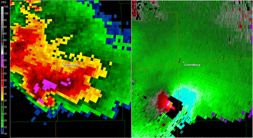
6. May 19th. Being able to see the Leedy, OK tornado from TCU to tornadogenesis was very cool. We were right on it from the beginning and only got closer and watched the tornado touchdown from under 1/2 mile way. I have a good video of tornadogenesis but want to make it a timelapse before I put it up.


Tornado!


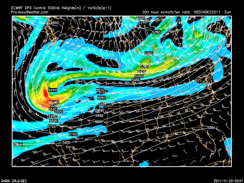
5. April 6th- After a chase bust the day before in northern MO, I was asleep the next morning and around 7am, I heard something pounding the roof. I knew instantly it was hail, most likely from leftover storms the night before that went through IA. I quickly ran downstairs with my camera and shot a good video of quarter to occasional golf ball sized hail pounding our deck in the backyard. The biggest hail I've seen at my house! Besides a tornado warning at 6am this past November, the hail was a great alarm! Here is a radar image of the storm that did the damage..probably about 70% of the homes in my neighborhood got new roofs because of the hail.

71dbz core!


http://www.youtube.com/user/MrTORN80#p/u/29/yrJGzvBpl6U


4. January 1st/2nd- LES event in northwest IN/southwest MI. Went over to the LES belt to document a setup that was expected to produce large amounts of snow with impressive snowfall rates. Adam, Sam, and I left during the evening on the 1st of the year to run into +SN as we neared the MI border and were lead by a state trooper at 30mph with snow covered highways. We then spent the whole night out in the band getting under the heaviest part of it. The next morning we spent in a BK in Watervliet, MI where they had near a foot of snow on the ground and going in and out of +SN the entire afternoon.


I shot this video outside of the BK under an intense LES band.

http://www.youtube.com/user/MrTORN80#p/u/45/fjzbnFxYYRk


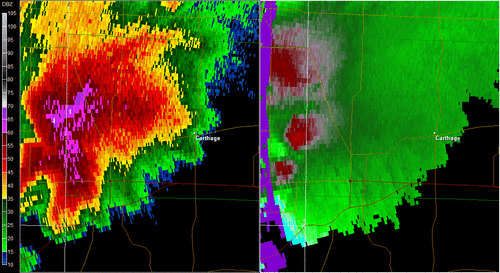
3. May 22nd- The famous Bowdle day without seeing the big monster tornado. We did see the first large tornado at a distance but thanks to power lines down on the road we had to go a good 30 minutes out of the way to get back into position only to end up a quarter mile north of a large rain wrapped tornado with baseball hail to our immediate north.


2. June 5th- Illinois tornadoes, This day was showing big potential for a few days along the warm front in IL with great mid-level support, instability, and lots of moisture. But...we were sitting in extreme southeast IA around 6pm socked under clouds with horrible low-level lapse rates and if someone would of told us we would see three great tornadoes before nightfall, the six of us wouldn't of believed it. We decided to drive back into IL through Burlington folling a descent shower that rapidly grew into a mini supercell and eventually putting down tornado after tornado for us from Yates City to Elmwood to just west of Peoria.

1st tornado

http://www.youtube.com/user/MrTORN80#p/u/19/28Kjo5FJv34


It was like a scene out of twister...driving on a gravel road with a small valley and then a hill and so on, and then going down into a valley we saw a funnel and 10 seconds later getting to the top of the hill it was on the ground! It was amazing the amount of lightning near this tornado!

http://www.youtube.com/user/MrTORN80#p/u/18/pVRzIRv8nos

2nd tornado


great structure!

3rd tornado on video

http://www.youtube.com/user/MrTORN80#p/u/16/1mKC2L0FFrw


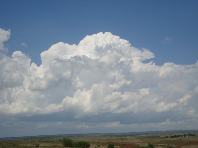
1. May 18th- It came down to my #2 pick and this one but I picked this day because the longevity of the day as well as seeing three different supercells that produced four tornadoes. Our target area this day was Dalhart, TX and didn't have to go that far after that to see what ended up being my favorite chase day of the year. We saw an amazing structured supercell near Dumas, TX that produced two brief tornadoes before this image.


radar image at the time of the picture above


this storm went on to produce another tornado Stinnett but we left it before that and hauled back west to catch another monster of a supercell that ended up giving me my first night tornado, and it was a big one!


after this, we caught another supercell directly to the northwest of this one, as it too, produced another large tornado just west of Stratford.


Here is to 2011 being just as good or even better, filled with lots of photogenic tornadoes and thundersnow!


Matt