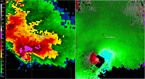
5/4/07-Greensburg EF-5
One of my favorite tornado events of all-time to go back and look at. Analyzing the entire synoptic and even more, mesoscale setup is amazing to me and how the hodograph dramatically near dark, left split after left split after left split then BOOM. The loop of the Greensburg supercell and its associated strong tornadoes is probably my favorite 4 hour loop of all-time. Whats amazing this the amount of occlusions and new mesocyclones that went on to produce more strong tornadoes, some at the same time. As you can see in this loop, the mesocyclone and Greensburg tornadoe starts to occlude just before hitting the town of Greensburg and begins to turn north and eventually northwest while the new meso really intensifies just east of town.
Create avatar">
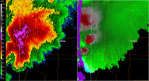
5/22/11 Joplin MO EF-5 (Joplin marked by the red dot)
The environment suggested the possibility of strong tornadoes in southwest MO but what amazes me is how quickly it spun up and you can get a sense in some of the videos of it showing it going from a funnel to a full blown wedge in seconds. You can also see the insane debris ball as debris was lifted up into the tornado aloft and picked up by the radar.
Make an avatar
