As usual I'll start off with a WV loop of what's going on..
http://weather.rap.ucar.edu/satellite/displaySat.php?region=EVV&itype=wv&size=large&endDate=20111020&endTime=-1&duration=12
Our shortwave is still back in eastern MT with jet max moving across parts of WY and into the Dakota's later this evening. A good amount of dry air seen south of this system and also what looks to be the uppel level jet screaming along near the WY/CO at the base of this trof with a bit of divergence seen as well. It's going to take till overnight for this thing to really get going and the mid-level low to close itself off but when it does we should see an expansion of precip in the deformation zone. As you can see below is the mid-level shortwave closing itself off and intensifying tomorrow morning as it moves into MN.
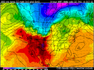
What is feeding this thing is the tight and impressive low-level baroclinic zone for it to ride along and feed off of. With it still being only early October there is still plenty of latent heat to be tapped. 850mb temps of 14 deg C into the circulation is damn impressive. Also much colder, canadian air will be dragged down.
What will determine amounts will not only be what the SLR ratios are (probably around 8:1) but when the changeover from rain to snow occurs. Now based off soundings and looking at thickness values, it should be somewhere between 6-9z overnight depending on a given location.
Overall this system should looking very impressive on both WV/sat as well as radar. Here is a forecast comp reflectivity (sim radar) for early tomorrow morning showing the large area of precip associated with the deformation zoneAnother thing to watch will be possible areas of blizzard conditions. It's not a setup that screams blizzard but models have been progging 925mb winds anywhere between 50-60kts...and if those are to mix down to the surface then obviously there could be a short period of blizzard conditions given the heavy rate of snowfall. Here is a forecast sounding for just west of GFK showing the potential and extreme winds just off the deck.
Add to that we could see snowfall rates of 1-2"/hr in the heaviest band given the strong UVV's being shown on fcst models, I wouldn't be shocked at some thundersnow either. Another thing when looking that sounding above is the depth of the dendritic growth zone (DGZ) which will tell you how well good a state the atmosphere is in making bigger snowflakes of dendrites. Looking like a >100mb deep DGZ for time which is fairly impressive.
Here is the 15z run of the SREF forecast snow totals which really ramped up from the previous runs. Will be interesting to see if this trend holds over the next few runs.
If I had to pick a max band area I'd say from near/north of GFK to extreme southeast Winnepeg near Lake of the Woods. I'd love to be up in northwest MN for this one. Anywhere from 10-14" looks like a good bet in that area. It will be a quick moving system but man is it going to pour snow. Things to hamper with totals will be warm ground and time of changover. But hopefully heavy rates will compensate.
Matt


No comments:
Post a Comment